We’d like to bring to you today a piece of news that was published before this blog existed, but which we think is extraordinarily interesting. We were reminded of it by Basques in Mexico, a mailing list of a group of diaspora Basques whose activity is really worthy of recognition.
This news is about research published in 2009 in the Journal of Human Evolution (which we’ve cited on other occasions) and headed by a group of researchers at the University of Zaragoza, which analyzed some rocks with paleolithic etchings dated to around 13,660 years ago, in the Abauntz cave in Navarre.

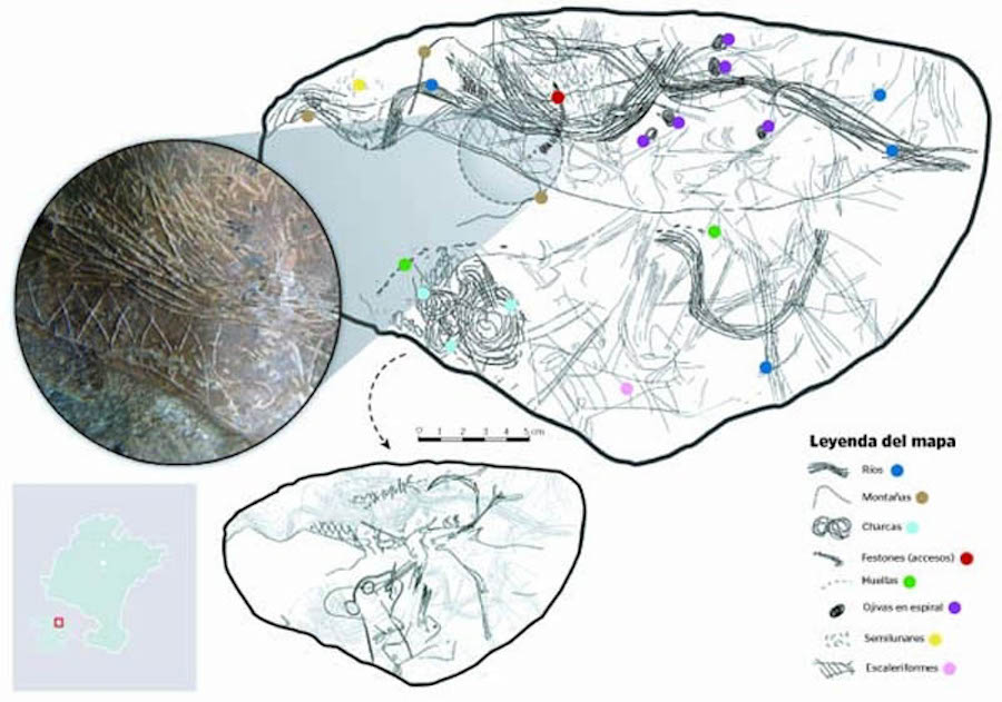
This is, accourding to the researchers, a map of the area around the cave, where geographical features like rivers, refuges, or mountains are, as well as paths and trails.
Those hunter-gatherers drew, over 13,000 years ago, on that rock animals, people, and a map which turns this artifact into one of the most important in European prehistory.
But, who were these people? Abauntz cave is found to the north of Pamplona, near the town of Arraiz-Orkin at the entrance to Baztán valley. This location, so close to this valley, is of fundamental importance to help us understand who made this prehistoric map.
As we said in an earlier entry which has become the most visited one on this blog: The Basques, a people with more than 15,000 years of history, which colonized Europe. In that entry, we talked about how genetic research at the University of the Basque Country performed on inhabitants of that valley from 15,000 years ago and today showed that they were directly connected. In other words, the Basques living in the Baztán today are the direct descendents of those who lived there 15,000 years ago.
Undoubtedly, those who etched that map more than 130 centuries ago wree part of the same ethno-genetic group, which means that they were the direct ancestors of today’s Basque.
We’ll finish off with a reference to the Journal of Human Evolution, a news article that appeared in Peru in those days, and an interesting post from the blog “Navarrese Archeology”.
Journal of Human Evolution – 8/2009 – USA
A palaeolithic map from 13,660 calBP: engraved stone blocks from the Late Magdalenian in Abauntz Cave (Navarra, Spain)
An engraved block from the cave of Abauntz is interpreted as a Magdalenian map in which the actual surrounding landscape, including mountains, rivers, and ponds, is represented. Some possible routes or avenues of access to different parts of the geography are also engraved on the landscape. The engraving seems to reproduce the meandering course of a river crossing the upper part of side A of the block, joined by two tributaries near two mountains. One of these is identical to the mountain that can be seen from the cave, with herds of ibex depicted on its hillsides, on both sides of the gorge in front of which the cave of Abauntz is strategically located.
(Continue) (Automatic translation)
———————–
Perú 21 – 5/8/20109 – Perú
Hallan grabado en una roca el mapa más antiguo de Europa
Un grupo de investigadores de la Universidad de Zaragoza identificó en la cueva de Abauntz (Navarra) unos grabados en unas rocas de hace 13,660 años que resultaron ser un mapa de la zona, informó la web de El País de España. Esta investigación, dirigida por la catedrática de Prehistoria de la Universidad de Zaragoza, Pilar Utrilla, y que ha durado 15 años, fue publicada en la revista digital Journal of Human Evolution.
(Continue) (Automatic translation)
———————–
Arqueología Navarra: Cueva de Abauntz
(Automatic translation)
—————–

Last Updated on Dec 20, 2020 by About Basque Country


